|
|
 EXPLORE
CAMBODIA THROUGH PHOTOGRAPHY EXPLORE
CAMBODIA THROUGH PHOTOGRAPHY |
 |
 |
 |
 |
|
Son La |
|
|
Thành phố Sơn La |
|
|
Address: |
|
|
|
|
|
Known as: |
|
|
|
|
|
Description: |
|
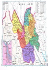
Son La is located in Northwestern Vietnam with its topography
fully describe geographical traits of this area of Vietnam with
many mountains, hills, rivers and mineral sources, surrounded by
primitive forests. Son La border quite many provinces such as
Lao Cai and Yen Bai to the North; Phu Tho and Hoa Binh to the
East; Dien Bien to the West; and Thanh Hoa and Laos to the
South.
This province was first appeared on Vietnamese map
during King Le Thanh Tong Dynasty in 1479 as a part of Hung Hoa
Province. The province has gone through a lot of changes in its
area before officially named Son La on 23/8/1964.
Son La used
to be a part of Viet Bac Interzone, consisting of the 6
Northwestern provinces that was headquarters of Vietnam
Communist Party and Viet Minh Government during resistance war
against French colonist in 1945. |
|
|
Province |
|
Son La |
Direction: |
|
|
|
|
District |
|
Son La |
|
|
|
City |
|
Son
La |
Comments: |
|
Official Web: |
|
|
|
|
Genre |
|
Scenery |
|
|
Related links: |
|
|
|
|
Best exposure |
|
N/A |
|
|
|
|
|
|
|
Rating |
|
     |
|
|
|
|
|
|
|
Opening time |
|
N/A |
|
|
|
|
|
|
|
Entry fee |
|
N/A |
|
|
GPS : |
|
21.32912, 103.90847 |
|
| |
|
|
|
|
|
|
|
|
|
|
|
 |


 |
 |
|
Click here to go back to
the previous page |
 |
| SUB-SITES PICTURES: |
|
|
 |
Son La area |
 |
xx |
|
|
|
 |
|
 |
|
Site
optimized for IE10 and Screen resolution above 1280X1024 |
|
Droits de reproduction et
diffusion reserves |
|
Copyright
© 2015 P-Lepetit.com / Asiaphotos.org |
|
Contact:
PatrickLEPETIT@hotmail.com |
|
|


