|
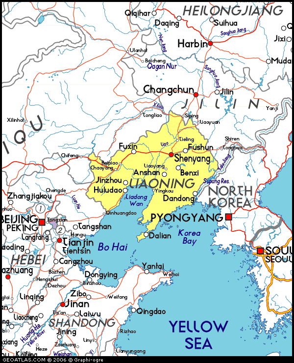
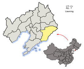
Dandong, formerly
known as Andong, is a coastal prefecture-level city in
southeastern Liaoning province, in the northeastern
region of People's Republic of China. It is the largest
Chinese border city, facing Sinuiju, North Korea across
the Yalu River, which demarcates the Sino-North Korean
border.
|
 |
|
|
DANDONG District |
|
|
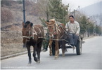 |
Dandong district landscape |
|
GPS: |
na |
|
N/A. |
|
|
| xxxxxxxxxxxxxxxxxxxxxx |
|
|
|
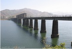 |
China-Korea Railway Bridge
(Yalu River Border Railway
Bridge) 鸭绿江国境铁路大桥 |
|
GPS: |
40.11514,
124.39029 |
|
N/A. |
|
|
| xxxxxxxxxxxxxxxxxxxxxx |
|
|
|
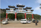 |
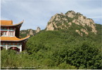
Da Gu Shan 大孤山 |
|
GPS: |
39.90758,
123.59838 |
|
The scenic area is not very
large or high but has a forest
of 1,000-year-old oak and gingko
trees. These trees have odd
shapes which have formed
naturally over centuries. At the
top of the mountain is the Queen
of Heaven temple built during
the Tang Dynasty. |
|
|
| xxxxxxxxxxxxxxxxxxxxxx |
|
|
|
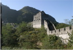 |
Hushan Great wall
虎山长城 |
|
GPS: |
40.23018,
124.50981 |
|
The Hushan or Tiger Mountain
Great Wall, known to Koreans as
Bakjak Fortress, is a wall in
China. The wall runs for about
1,200 metres over Hushan. The
wall starts directly beside the
China–North Korea border. |
 |
|
| xxxxxxxxxxxxxxxxxxxxxx |
|
|
|
 |
Peace gulf reservoir |
|
GPS: |
40.3651,
124.73292 |
|
N/A. |
|
|
| xxxxxxxxxxxxxxxxxxxxxx |
|
|
|
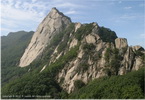 |
Phoenix mountain
凤凰山 |
|
GPS: |
40.42783,
124.07419 |
|
Phoenix Mountain, also known by
its Chinese name Fenghuangshan,
is a mountain located in
Fengcheng, Dandong Prefecture,
Liaoning Province, China. Its
highest peak is called Jianyan
with a height of 836 meters
above sea level. |
|
|
| xxxxxxxxxxxxxxxxxxxxxx |
|
|
|
 |
Qinshangou |
|
GPS: |
na |
|
N/A |
|
|
| xxxxxxxxxxxxxxxxxxxxxx |
|
|
|
 |
Aihe river |
|
GPS: |
40.2183,
124.51217 |
|
N/A |
|
|
| xxxxxxxxxxxxxxxxxxxxxx |
|
|
|
|
 |
Shuifeng reservoir |
|
GPS: |
na |
|
N/A |
|
|
| xxxxxxxxxxxxxxxxxxxxxx |
|
|
|
 |
Wulong shan
五龙山 |
|
GPS: |
40.25514,
124.33549 |
|
Wulong Mountain has always been
a famous tourist attraction in
east Liaoning. Wulong Mountain
enjoys elegant and beautiful
natural scenery, and its
cultural landscape is
far-reaching. The original
Lingfeng Temple on the mountain
was built in the late Ming
Dynasty and was later destroyed
during times of trouble. |
|
|
| xxxxxxxxxxxxxxxxxxxxxx |
|
|
|
 |
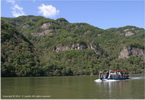
Yalu river
鸭绿江 |
|
GPS: |
40.24063,
124.56 |
|
The Yalu River, also called the
Amrok River or Amnok River, is a
river on the border between
North Korea and China. Together
with the Tumen River to its
east, and a small portion of
Paektu Mountain, the Yalu forms
the border between North Korea
and China. |
|
|
| xxxxxxxxxxxxxxxxxxxxxx |
|
|
|
|
|
DANDONG City |
|
|
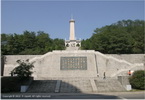 |
Memorial of the War to Resist US
Aggression
抗美援朝纪念馆 |
|
GPS: |
40.11953,
124.36685 |
|
The Memorial Hall for the War to
Resist US Aggression and Aid
Korea is situated where the
command post of the Volunteer
Army was located. The memorial
was built in 1958. |
|
|
| |
|
|
|
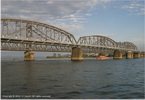 |
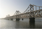
Broken Bridge
鸭绿江断桥 |
|
GPS: |
40.11514, 124.39029 |
|
The Yalu River Broken Bridge is
a truncated railway swing bridge
converted to a viewing platform
and historical site. Constructed
in 1911 by the Empire of Japan,
it was the first bridge built
across the Yalu River and
connected the Chinese city of
Dandong with the Korean city of
Sinuiju. During the Korean War,
the eight spans over the Korean
side of the river were badly
damaged by American bombing, and
were subsequently dismantled. |
|
|
| |
|
|
|
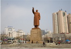 |
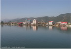
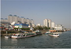
Dandong city
丹东 |
|
GPS: |
40.12546,
124.38011 |
|
Dandong, formerly known as
Andong, is a coastal
prefecture-level city in
southeastern Liaoning province,
in the northeastern region of
People's Republic of China. It
is the largest Chinese border
city, facing Sinuiju, North
Korea across the Yalu River,
which demarcates the Sino-North
Korean border. |
|
|
| |
|
|
|
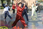 |
Morning exercises |
|
GPS: |
na |
|
N/A |
|
|
| |
|
|
|
 |
Friendship bridge 中朝友谊桥 |
|
GPS: |
40.11478,
124.39286 |
|
The Sino-Korean Friendship
Bridge or China–North Korea
Friendship Bridge is a bridge
across the Amnok River on the
China–North Korea border. It
connects the cities of Dandong
in China and Sinuiju of North
Korea via railway and roadway
but pedestrians are not allowed
to cross between either side. |
|
|
| |
|
|
|
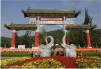 |
Jinjiang park
锦江山公园 |
|
GPS: |
40.13276,
124.38046 |
|
N/A |
|
|
| |
|
|
|
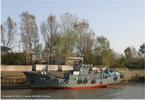 |
Korea Riverside |
|
GPS: |
40.099,
124.37917 |
|
N/A |
|
|
| |
|
|
|
 |
Yalu river 鸭绿江 |
|
GPS: |
40.24063,
124.56 |
|
The Yalu River, also called the
Amrok River or Amnok River, is a
river on the border between
North Korea and China. Together
with the Tumen River to its
east, and a small portion of
Paektu Mountain, the Yalu forms
the border between North Korea
and China. |
|
|
| |
|
|
|
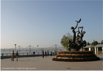 |
Yalu Riverside / Yalujiang Park
鸭绿江公园 |
|
GPS: |
40.12421,
124.39514 |
|
For views of the border, stroll
along the narrow riverfront Yalu
Jiang Park, which faces the
North Korean city of Sinuiju. |
|
|
| |
|
|
|
|