  HOTAN area
 |
|
|
 |
Atlas silk factory
艾德莱斯绸 |
|
GPS: |
37.07366,
80.18512 |
|
Jiya township is renowned
for its Atlas Silk. In the
Uyghur language the word atlas
means "tie-dyed silk." Among the
traditional products of the
Hotan region, Atlas Silk dates
from 2,000 years ago.
Traditional motifs of the Hotan
region are portrayed in Atlas
Silk fashions. |
|
|
|
|
|
|
 |
Hotan
Carpet market |
|
GPS: |
na |
|
N/A. |
|
|
|
|
|
|
 |
Coal sellers |
|
GPS: |
na |
|
N/A |
|
|
|
|
|
|
 |
Commercial street |
|
GPS: |
na |
|
N/A |
|
|
|
|
|
|
 |
Tarim Desert |
|
GPS: |
na |
|
Apart from historical relic of
two thousand years, there are
spectacles of the second largest
desert in the world, Takla
Makan. The Tarim Desert Highway
across the 'ocean of death' from
north to south is nowadays a
convenient external passageway
of Hetian and an ideal locality
to admire the scenery in
hinterland of desert.. |
|
|
|
|
|
|
 |
Hotan-Karghlik Road |
|
GPS: |
na |
|
N/A |
|
|
|
|
|
|
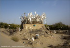 |
Imam Asim Ancient Tomb |
|
GPS: |
37.24051, 80.04258 |
|
The Imam Asim tomb is belong to
a Muslim missionary who was also
a military officer in the 11th
century, who came from central
Asia to Hotan to convert the
people in to Islam. He was died
during his Jihad in this place
so the people named this place
with the name of Imam Asim to
show the respect to him. |
 |
|
|
|
|
|
 |
Hotan
Jades |
|
GPS: |
na |
|
Since ancient times, Hotan
has been known as rich in jade
resources, especially the white
jade resources. In history, the
king of the State of Yutian
always sent jade presents to the
rulers in the inland as tribute.
The major deposits of Hotan jade
are tucked away deep in the
loftyKunlun Mountains. The most
famous kinds of Hotan jade are
suet jade, black jade, and
jadeite. |
|
|
|
|
|
|
 |
Local bakery |
|
GPS: |
na |
|
N/A |
|
|
|
|
|
|
 |
Melikawat
Ruins 买力克阿瓦提古城 |
|
GPS: |
36.94654,
79.89595 |
|
Melikawat is a Tang dynasty
settlement with wind-eroded
walls, Buddhist stupas and the
remains of pottery kilns. Some
scholars believe Melikawat was a
capital city of the Yutian state
(206 BC to AD 907), an
Indo-European civilisation that
thrived during the height of the
Silk Road. |
|
|
|
|
|
|
 |
Minaret-Mosque-Architecture |
|
GPS: |
na |
|
N/A |
|
|
|
|
|
|
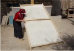 |
Mulberry
paper making
桑皮造纸和田 |
|
GPS: |
37.26099,
79.73035 |
|
Mulberry paper making is a
traditional handicraft of the
Uyghur people in China's
Xinjiang. It is handmade and
today only a few families still
produce it in Moyu County. The
finished product is graded as
high, medium, or low, according
to quality. In the Qing Dynasty
(1644-1911 AD), books and
brochures were mainly printed
with high-quality paper in
Xinjiang. It was also used to
print money during the period of
the Republic of China (1912-1949
AD). |
|
|
|
|
|
|
 |
Tuanjie Square
团结广场 |
|
GPS: |
37.11069,
79.9229 |
|
Tuanjie Square or Unity Square
is the main square in the center
of Hotan. It is so called to
promote unity among the various
ethnic minorities in the region,
where the Uyghur people are in
the majority. |
|
|
|
|
|
|
 |
Restaurant-Pasta maker |
|
GPS: |
na |
|
N/A |
|
|
|
|
|
|
 |
Sunday market-Bazar
和田周日市场 |
|
GPS: |
na |
|
The weekly Sunday market in
Hotan offers a wider variety of
goods, and still exists
primarily to serve the needs of
the residents of the city that
includes Uyghurs, Tajiks,
Uzbeks, Kyrgyz, and Chinese. |
|
|
|
|
|
|
 |
Sunday
Livestock market |
|
GPS: |
na |
|
na |
|
|
|
|
|
|
|
KARGHILIK area
叶城 |
|
|
 |
Central square-Market
大巴扎 |
|
GPS: |
37.88295,
77.41239 |
|
N/A |
|
|
|
|
|
|
 |
Charbagh
market |
|
GPS: |
na |
|
N/A |
|
|
|
|
|
|
 |
Jama Masjid |
|
GPS: |
37.88169, 77.41362 |
|
N/A |
|
|
|
|
|
|
 |
Small
restaurant |
|
GPS: |
na |
|
N/A |
|
|
|
|
|
|
|
KASHGAR area |
|
|
 |
Basche Khram Mou |
|
GPS: |
na |
|
N/A |
|
|
|
|
|
|
 |
Bulak Su
Village |
|
GPS: |
na |
|
N/A |
|
|
|
|
|
|
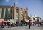 |
Kashgar City 喀什市 |
|
GPS: |
39.46768, 75.99378 |
|
Kashgar is a city in the
Xinjiang Uyghur Autonomous
Region, in China’s far west. It
was a stop on the Silk Road,
with its history stretching over
2,000 years. Today it’s known
for the Kashgar Sunday Bazaar, a
daily market crammed with
pashminas, spices, fur caps and
more. Another major site is the
15th-century Idkah Mosque, which
can house up to 20,000
worshipers. |


 |
|
|
|
|
|
|
|
 |
Abakh Hoja tomb
阿巴和加麻札 |
|
GPS: |
39.49104,
76.02575 |
|
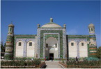
Apak Hoja Tomb is the tomb of
Apak Hoja and the families. As
the largest Islamic mausoleum in
China, Apak Hoja Tomb covers an
area of 20,000 square meters,
composed of gate tower, great
mosque, small mosque, scripture
hall and main tomb chamber. |
 |
|
|
|
|
|
|
|
Carpet market |
|
GPS: |
na |
|
N/A |
 |
|
|
|
|
|

 |
City-Architecture
喀什市 |
|
GPS: |
39.46768,
75.99378 |
|
The city of Kashgar is located
where the Taklamakan Desert
meets the Tianshan Mountains.
For more than a thousand years,
it was a key hub along the
ancient Silk Road, connecting
China's Yellow River Valley with
India and the Mediterranean.
Kashgar is also known for its
Uyghur-style homes. |
 |
|
|
|
|
|
 |
Grand Bazar-Sunday market
喀什中西亚国际贸易市场 |
|
GPS: |
39.47452,
76.00536 |
|
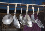
As the important city on the
ancient silk road, and it was
also one of the main commodity
distribution centres at that
time. Kashgar Grand Bazaar has a
history of more than 2000 years
and it is the largest
international trade market in
Northwest of China. |
 |
|
|
|
|
|
 |
Id Kah Mosque 艾提尕尔清真寺 |
|
GPS: |
39.4704,
75.98975 |
|
The Mosque was first built in
1442 and has a history of over
500 years. The building complex
is in grand Islamic style, with
strong religious features
consisting of a gate tower, a
courtyard, a doctrine-teaching
hall, and a large Hall of
Prayer. |
 |
|
|
|
|
|
|
|
Mao Tse Tung statue
毛泽东雕像 |
|
GPS: |
39.4679,
75.99248 |
|
nOn the main thoroughfare
outside People's Park stands a
large statue of Mao Zedong, with
a hand raised toward the park. |
 |
|
|
|
|
|
|
|
|
|
|

 |
Kashgar Old city
喀什噶尔老城 |
|
GPS: |
39.47412,
75.99232 |
|
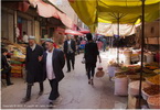
Kashgar’s Old City has been
known for centuries as a unique
ancient city in Central Asia.
Most know the place for its Silk
Road charm, mud-brick houses and
friendly Uyghur neighborhoods.
Kashgar’s Old City history has
been resilient in the face of
passing time. |
 |
|
|
|
|
|
|
|
Old street |
|
GPS: |
na |
|
N/A |
 |
|
|
|
|
|
|
|
Pan Tuo City 盘橐城 |
|
GPS: |
39.45382,
76.00599 |
|
Pantuo City, also known as
"Aisksa", is situated near by
the Tuman River southeast of
Kashgar. In the early nineteen
century French explorer Paul
Pelliot prospected for the area.
According to his notes, ramparts
of the city were built along
sthe north and the east borders
of the township, with a length
of 287 meters and 205 meters
respectively and a foundation of
7-meter wide. Pantuo had always
had substantial political and
economic importance for several
dynasties historically. The
palace of Shule State was
located in Pantuo in 170 A.D. |
 |
|
|
|
|
|
|
|
Peoples square 人民广场 |
|
GPS: |
39.46665,
75.99275 |
|
People's Park is an urban public
park in the city of Kashgar. The
24-hectare park is one of the
largest in Kashgar. It is one of
the main recreational places in
the city. |
 |
|
|
|
|
|
|
|
Sunday Livestock market |
|
GPS: |
na |
|
The livestock market that’s
located about 10km outside of
town. Here you can buy, camels,
sheep, cows, donkeys etc., but
no pork since this is the
Islamic part of China. |
 |
|
|
|
|
|

|
Yusuf
Khass Hajib Mausoleum
玉素甫·哈斯·哈吉甫墓 |
|
GPS: |
39.45851,
75.99496 |
|
The Mausoleum of Yusuf Khass
Hajib was build in honor of the
famous philosopher and preacher.
He was living in the XI century.
The writer was born in one of
the two capitals of Karakhanids
- Balasagun (Kyrgyzstan), so he
is sometimes called Balasaguni.
However, almost all his life
Yusuf Khass Hajib lived in
Kashgar and died in Kashgar in
1085. |
 |
|
|
|
|
|
|
|
|
 |
Ha Noi
ruins- Mor Pagoda |
|
GPS: |
na |
|
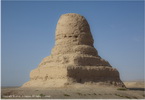
The ruins of Ha Noi, a
Tang-dynasty town built in the
7th century were abandoned in
the 12th century. Little remains
apart from an enigmatic
pyramid-like structure and the
impressive four-tiered Mor
Pagoda. |
|
|
|
|
|
|
 |
Kashgar - Khunjerab Road |
|
GPS: |
36.85003,
75.43187 |
|
N/A |
 |
|
|
|
|
|
|
|
|
|
Comer lake (Bulung Kul) |
|
GPS: |
38.71371,
75.00543 |
|
Comer Lake (Bulung Kul) is a
tranquil shallow lake. Flowing
into this lake is the Gaz River,
originating from the Karakul
Lake, this river carries sand to
the lake which has then been
picked up by the wind and blown
to create impressive sand
covered mountains on the far
side. |
 |
|
|
|
|
|
|
|
Ghez river canyon |
|
GPS: |
na |
|
N/A |
 |
|
|
|
|
|
|
|
Road view |
|
GPS: |
na |
|
N/A |
 |
|
|
|
|
|
|
|
Kala Kule Lake - Muztagh Ata
Mount قاراكۆل
克州喀拉库勒湖 |
|
GPS: |
38.44163,
75.04973 |
|
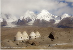
The Karakul or Karakuli is a
lake located 196 km southwest of
Kashgar. It is located in Akto
County, Kizilsu Kirgiz
Autonomous Prefecture on the
Karakoram Highway, before
reaching Tashkurgan, the
Khunjerab Pass on the China -
Pakistan border. |
 |
|
|
|
|
|
|
|
Kumtagh plateau |
|
GPS: |
na |
|
N/A. |
 |
|
|
|
|
|
|
|
Truck accident |
|
GPS: |
na |
|
N/A |
 |
|
|
|
 |
Kashgar-Urumuqi sky view |
|
GPS: |
na |
|
N/A |
|
|
|
|
|
|
 |
Leng Gar village |
|
GPS: |
na |
|
N/A |
|
|
|
|
|
|
 |
Mahmud
Kashgari tomb
محمود الكاشغري |
|
GPS: |
na |
|
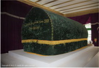
The tomb of the famous Uyghur
scribe who compiled a dictionary
of the Turkic languages in the
11th century. You can find out
his life and contribution to the
local culture. This picturesque
complex is situated on a
hillside and includes a mosque
and a sacred spring where he
planted his staff that grew into
a great tree. |
|
|
|
|
|
|
|
TURPAN area |
|
|
 |
Astana-Karakhoja Ancient Tombs
阿斯塔那古墓群 |
|
GPS: |
42.8789,
89.52921 |
|
Astana-Karakhoja Ancient Tombs
is a burial ground of Tang
Dynasty (618-907). The name
"Astana" means "Capital" in the
Uighur language. And "Karakhoja"
is the name for a legendary
Uygur Kingdom hero who protected
the people by slaying a vicious
dragon. Served as a public
cemetery for Ancient City of
Gaochang, these tombs were
gradually formed from the 3th to
8th century and have a history
of more than 2,000 years. |
 |
|
|
|
|
|
 |
Aydingkul
lake
艾丁湖 |
|
GPS: |
42.66128,
89.27047 |
|
The lake is located in the south
hinterland of the Turpan
Depression. From east to west,
the lake spans 40 kilometres;
the north-south span is 8
kilometres; and the total area
of the lake is 200 square
kilometres. The lake was formed
from the formation of an orogeny
of the Himalayas 249 million
years ago, and once held
approximately 5 million square
kilometres of inland sea. |
 |
|
|
|
|
|
 |
Turpan Bazar |
|
GPS: |
42.94149, 89.17949 |
|
Bazaar centrally located in
Turpan. This is very much a
working market for the local
Uyghur population, large
entrance but soon becomes a maze
of alleys packed full of locals
buying clothes, household goods,
carpets, food, toys and
everything else under the sun.
The meat section is worth
seeing... |
|
|
|
|
|
|
 |
Bezeklik
caves
柏孜克里克千佛洞 |
|
GPS: |
42.95731,
89.54234 |
|
The Bezeklik Thousand Buddha
Caves is a complex of Buddhist
cave grottos dating from the 5th
to 14th century between the
cities of Turpan and Shanshan
(Loulan) at the north-east of
the Taklamakan Desert near the
ancient ruins of Gaochang in the
Mutou Valley. |
|
|
|
|
|
|
 |
Emin minaret 苏公塔 |
|
GPS: |
42.93462,
89.20339 |
|
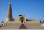
Built to honour Turpan general
Emin Hoja, this splendid
44m-high mud-brick structure is
the tallest minaret in China.
Named Sūgōng Tǎ after Emin’s son
Suleiman, who oversaw its
construction (1777–78), its
bowling-pin shape is decorated
with an interesting mix of
geometrical and floral patterns:
the former reflect traditional
Islamic design, the latter
Chinese. |
 |
|
|
|
|
|
 |
Flaming
montains (Huo Yan
Shan)
火焰山 |
|
GPS: |
42.94484,
89.52969 |
|
Flaming Mountains are so named
because in the evenings the red
clay mountains reflect the heat
and glow of the desert and seem
to burn. |
 |
|
|
|
|
|
 |
Gaochang ruins
高昌 |
|
GPS: |
42.85955, 89.53192 |
|
The foundation of Gaochang was
laid in the 1st century BC. The
city was built during the
Western Han Dynasty and re-built
in the early Ming Dynasty. It
was an important site along the
Silk Road, but was burnt down in
wars in the 14th century.
Gaochang Ancient City was the
capital of the Gaochang kingdom,
located 40 kilometers east of
Turpan city Sanbao village. |
|
|
|
|
|
|
 |
Grapes
Valley
葡萄沟 |
|
GPS: |
42.97873,
89.22946 |
|
The Grape Valley is located in
the Flaming Mountain, 13
kilometers northeast of Turpan.
The valley runs 8 kilometers (5
miles) from north to south with
a width of 0.5 kilometers. This
green paradise of 400 hectares
(988 acres) is filled with
intertwined grape vines that
sport layer after layer of
luscious grapes. |
 |
|
|
|
|
|
 |
Jiaohe ruins
交河故城 |
|
GPS: |
42.95324,
89.06605 |
|
Jiaohe or Yarkhoto is a ruined
city in the Yarnaz Valley. It
was the capital of the Jushi
Kingdom. It is a natural
fortress located atop a steep
cliff on a leaf-shaped plateau
between two deep river valleys.
From 108 BC to 450 AD Jiaohe was
the capital of the Anterior
Jushi Kingdom. It was an
important site along the Silk
Road trade route. |
 |
|
|
|
|
|
 |
Karez
museum (Kan'erjing Museum)
吐鲁番坎儿井博物馆 |
|
GPS: |
42.95302,
89.14903 |
|
This museum is dedicated to the
uniquely Central Asian–style
irrigation system that includes
hundreds of kilometres of above
and underground canals, wells
and reservoirs, much of it still
working. |
 |
|
|
|
|
|
 |
Peoples
square |
|
GPS: |
na |
|
N/A |
|
|
|
|
|
|
 |
Petroleum
fields |
|
GPS: |
na |
|
N/A |
|
|
|
|
|
|
 |
Mansion of the prefect of Turpan |
|
GPS: |
na |
|
The mansion was first built
during the Qing dinasty between
1736-95, while the current
structures have been rebuilt
recently according to ancient
records. The mansion consists of
a number of buildings and halls. |
|
|
|
|
|
|
 |
Tuyoq
village (Tu Yugou)
吐峪沟麻扎村 |
|
GPS: |
42.85457,
89.69075 |
|
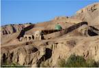
Set in a green valley fringed by
the Flaming Mountains, this
mud-brick village offers a
fascinating glimpse of
traditional Uyghur life and
architecture. It has been a
pilgrimage site for Muslims for
centuries, as on the hillside
above is the Hojamu Tomb, a
mazar (a tomb of a saint or holy
person), said to hold the first
Uyghur to convert to Islam. |
|
|
|
|
|
|
 |
Others |
|
GPS: |
na |
|
na |
|
|
|
|
|
|
|
URUMUQI area |
|
|
 |
Urumuqi
乌鲁木齐 |
|
GPS: |
43.82559,
87.61684 |
|
Ürümqi or Urumchi, abbreviated
Wushi, formerly known as Tihwa,
is the capital of the Xinjiang
Uygur Autonomous Region in the
far northwest of the People's
Republic of China. |
 |
|
|
|
|
|
|
|
 |
Urumuqi
City
乌鲁木齐 |
|
GPS: |
43.82559,
87.61684 |
|
Urumqi is a city that is
geographically located in a
valley among the TianShan, the
mountain range that essentially
cuts Xinjiang in half. Over the
past couple decades it has
become a crowded city which is
thankfully not a far drive from
beautiful nature. |
 |
|
|
|
|
|
|
|
Erdaoqiao-International market
二道桥市场 |
|
GPS: |
43.78122,
87.61705 |
|
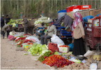
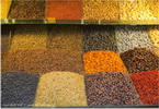
Erdaoqiao Bazaar located at the
southern end of Tianshan area in
Urumqi Erdaoqiao business
circle. Completed in June 26,
2003, is the world's largest
grand bazaar. Erdaoqiao Bazaar
is a combination blocks of
modern and ancient islamic
style, blue and silver dome roof
is imposing and magnificent, and
it is the window of the
Xinjiang. |
 |
|
|
|
|
|

|
Hongshan Park
红山公园 |
|
GPS: |
43.8089,
87.60465 |
|
Red Hill Park (红山公园, Hong Shan
Gong Yuan) is basically in the
center of the city of Urumqi and
is easy to find since the hill
is noticeable with a nine-story
red brick pagoda called Zhen
Long Ta on top. It is uncertain
when the pagoda was built. In
the evenings, the hill might
glow red in the sunlight. |
 |
|
|
|
|
|
|
|
People' s Park
乌鲁木齐人民公园 |
|
GPS: |
43.79686,
87.60506 |
|
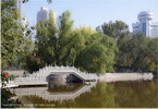
A green oasis with manicured
grounds and a ceremonial pagoda
in its centre, around which
visitors may paddle little boats
in the summer months. Like most
parks here, its perimeters are
sealed with high fences and
razor wire. |
 |
|
|
|
|
|

|
Southern Mosque |
|
GPS: |
43.78025,
87.61665 |
|
N/A |
 |
|
|
|
|
|
|
|
Yang Hang Mosque |
|
GPS: |
na |
|
N/A |
 |
|
|
|
 |
Tian Chi lake
天池 |
|
GPS: |
43.88803, 88.13523 |
|
Tianchi Lake, or Tianshan
Tianchi Lake, or some people
prefer Heavenly Lake, is located
at the hill side of Bogda Peak
in Fukang City. With an altitude
of 1980m, it's a natural
crescent alpine lake. The lake
is 3.5km from east to west, and
0.8km ~ 1.5km from north to
south, with maximum depth of
105m. |
 |
|
|
|
|
|
 |
Urumuqi
sky view-Airport |
|
GPS: |
na |
|
N/A |
|
|
|
|
|
|
|
YARKAND area |
|
|
 |
Altyn
Mosque complex
阿爾丁清真寺 |
|
GPS: |
na |
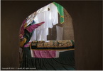
The Altyn Mosque is a mosque in
Yarkand in Yarkant County. It is
noted for its painted ceilings
and the tomb of the poet
Amannisa Khan (1526-60) which is
in its courtyard. She was the
wife of one of the local Khans.
Beyond the mosque is a cemetery
housing the tombs of the Khans
of Yarkand. |
 |
|
|
|
|
|
 |
Ha Stiper tomb complex |
|
GPS: |
na |
|
Hn. |
 |
|
|
|
|
|
 |
Yarkand Mosque |
|
GPS: |
na |
|
T. |
|
|
|
|
|
|
 |
Mosque square |
|
GPS: |
na |
|
T. |
|
|
|
|
|
|
 |
Yarkand
Old city |
|
GPS: |
na |
|
na |
 |
|
|
|
|
|
|
GOBY - TAKLIMAKAN desert sky
view |
|
|
 |
Gobi-Taklimakan desert sky view
塔克拉玛干沙漠 |
|
GPS: |
34.90736,
79.11248 |
|
The Taklamakan Desert has an
area of 337,000 km2, making it
slightly smaller than Germany
and is part of the Tarim Basin,
which is 1,000 kilometres long
and 400 kilometres wide. It is
crossed at its northern and at
its southern edge by two
branches of the Silk Road as
travellers sought to avoid the
arid wasteland. |
 |
|
|
|
|
|


